
Anapra Mesa
NOTE: SOME OF THE INFORMATION HERE MAY NOT BE CURRENT. PLEASE GO TO THE RIO GRANDE SOARING ASSOCIATION SITE GUIDE FOR THE MOST CURRENT INFORMATION.
31.786567° -106.582500° 4,081' MSL 200' AGL
General Info
USHPA required notification: The RGSA recommends that you do not fly at this site as it is not a chapter managed site. If you do choose to fly at this site, you must take full responsibility for your actions, and recognize that you are fully and solely liable for any damage incurred by yourself, to others, or to others’ property. This site is unimproved with significant safety issues, including potentially challenging wind and thermal conditions. Flying at this site can be risky to the pilot, property owners, and our sport as a whole. This site is unpermitted, uninsured, unmanaged, and unimproved. This site is, however, a Southwest Airsports training site, insured, and is used by its students.
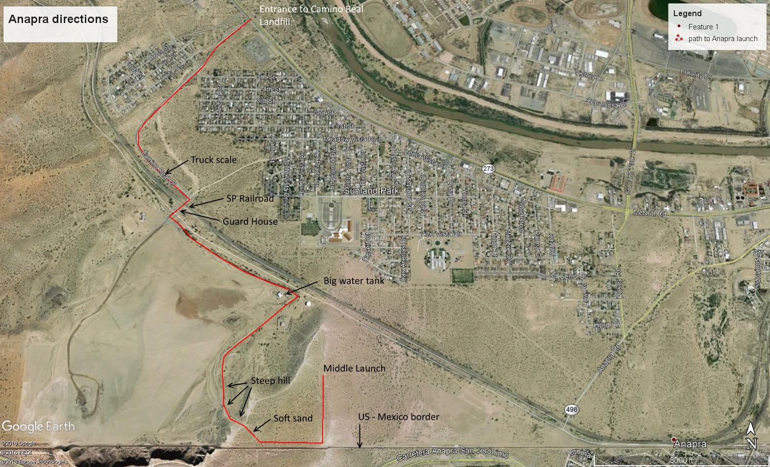
Go to the Camino Real Landfill (31.806763° -106.588187°) entrance and then follow (print out) the directions to launch. You have to go through guarded private property to reach launch. Visitors must tell the guards at the landfill that they are there for flying the mesa. We have the kind permission of the Camino Real Landfill superintendent, Dr. Juan Carlos Tomas, to trespass. If you want to bring the guards a 6-pack of cold beer/soft-drinks, it would not hurt....
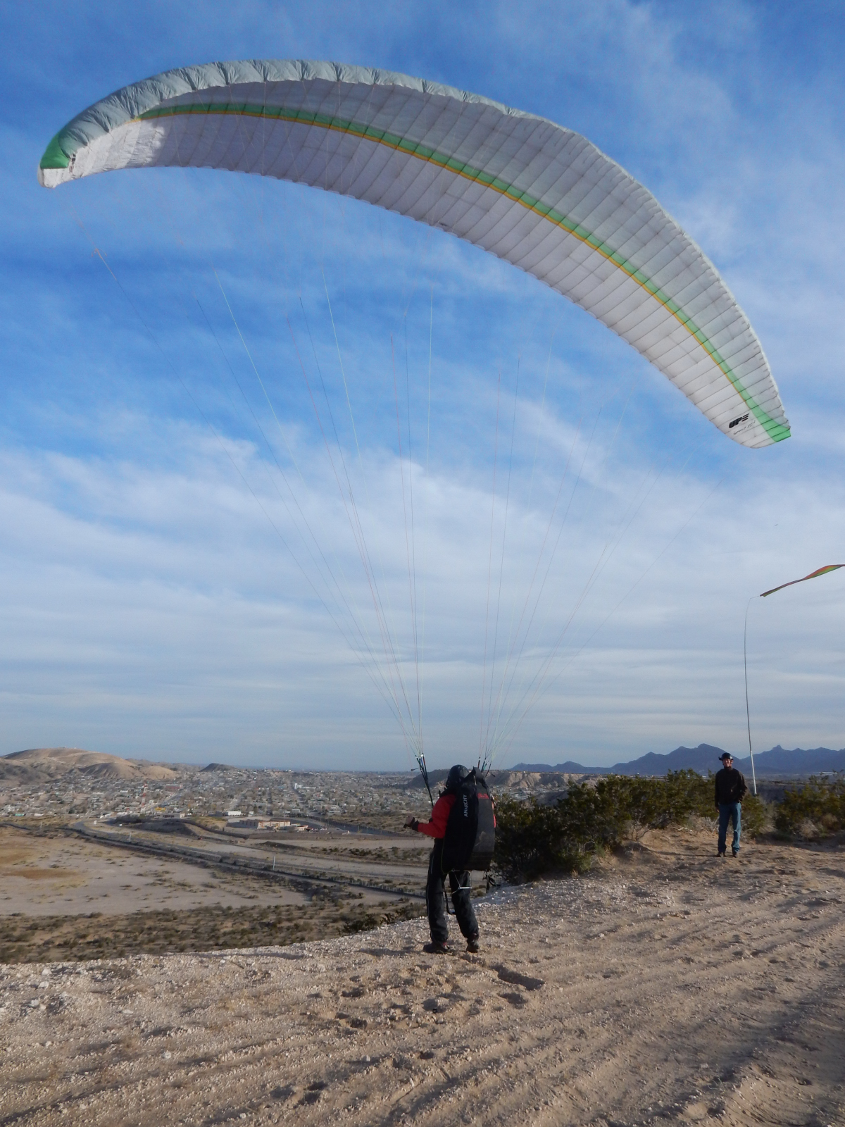
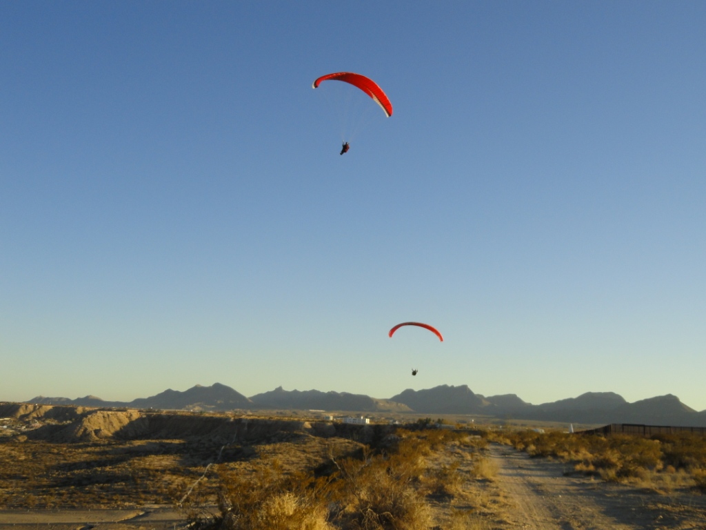
Center launch – view is SE. Winds were about 7-8, just barely strong enough to stay up out in front of the Mesa with an efficient glider. Below, Lee Boone (deceased) kites at the middle launch with Matt Hayes observing.
When to fly
It is only soarable with ENE to SSE winds. SE is always the best. Because of the Pass, winds at launch will always be slightly cross (~20°) to the right. If they are anything else pilots can expect some turbulence. Velocity needs to be from 8-14 mph for PG. How to tell without a wind gauge? If the tops of the Creosote bushes at the rim edge are swaying less than 3-4", conditions are too weak to stay up.
Typically, the weather models that are accurate per speed are usually: ECMWF, NAM3, & HRRR. Wind direction from the models can vary from actual conditions at launch. ECMWF and HRRR are usually the most accurate per speed and direction. It is a good idea to look at various stations up and downwind from the site, such as the Juarez Airport and the Santa Teresa Border Station. The site easily blows out and winds tend to go south late in the day. If the stations show a solid E, ESE, or SE direction, you should be good to go.
This
PowerPoint presentation by Tom Bird of the National Weather Service gives a number of forecasts and observations that will help pilots to accurately
determine the best time to soar Anapra. It is somewhat technical but worth the effort to learn how to read weather models and observations which dramatically improves pilot safety.
Site info
Located near the US-Mexican
border, it is perfect for new pilots as it has few hazards. The LZ is
huge and flat. The site is almost all soft sand and is forgiving of
hard landings and other mistakes. Warning: the ridge itself is a
calcified escarpment that is sharp and will cut glider lines if they are
dragged across it.
There is significant rotor all along the Mesa
close to the rim. Thankfully, the center launch has an elevated row of
non-hostile bushes that you can lay your glider on so that it will be elevated
about 4'. This is just enough to get out of the rotor for an easy
inflation. If you are not an experienced kiter, be sure to have help
when launching as you do NOT want to be dragged into the barbed-wire fence just behind launch. The New Mexico Environmental Protection Agency requires that landfills have their boundaries
fenced and the fence here, while not really doing anything, must remain per New Mexico State law.
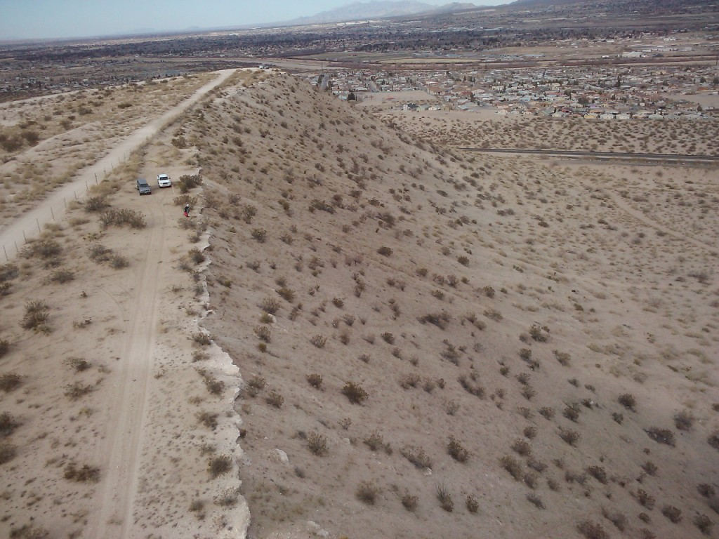
The south half of Anapra Mesa. Launch is just behind where this photo was taken. Skilled pilots can "park" above the mesa. View here is south.
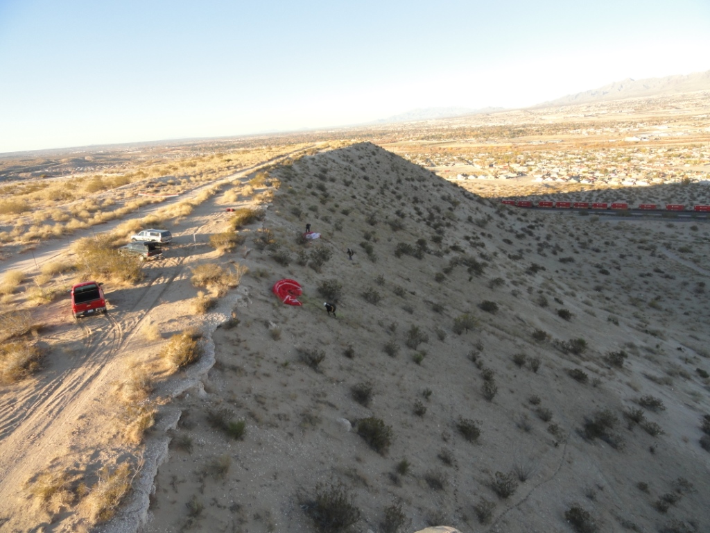
The best launch is close to the middle of the mesa where a
deep notch comes through. The notch causes the air to flow more
smoothly over this part of the rim so there is less turbulence and rotor at
launch. It is possible to kite here.
View below is looking north.
The barb wire fence behind the launch area is visible.
In the photo below, pilots can be seen preparing to launch. The far pilot is setting up just below the center launch area (a red bag is just visible). Spreading out below the rim is ALWAYS the safest because if you have a mishap inflating, you will NOT be blown into the barb wire fence that goes along the east edge of the dirt road. These pilots had never flown the site which is why the site guide asked them to launch below the rim. The downside of launching below the rim is that there is more plant debris that can get caught in your glider lines. Skilled desert pilots will know what to do.
The south end tends to have more turbulence because of the high border fence. Launching from the south area of the mesa is fine but you will find there is a lot of rotor because of the sharp cliff. This makes getting your glider up more difficult. If you move away from the edge about 15 yards it is usually possible to get out of the rotor enough to inflate. Once your glider is up, there is no rotor and you can move towards the edge easily.
Pilots can easily top land
anywhere. The south end is safer because the barb wire fence is farther
away. If you want to work on your side-hill landing skills, this is
the place to do it – it's all soft sand and is very forgiving of major
errors. If your wing goes into a bush, be prepared to spend some time
getting it out.
When launching from the middle launch area, turn north
(though downwind) and fly to near the north end of the mesa. The best lift
is between the middle and the north end of the mesa. If you launch and can't
keep level with the mesa, you are probably going to sink out. Turn south and
side-hill land anywhere on the hill in the soft sand.
The Second Wave
Skilled pilots can catch the Second Wave and park hundreds of feet over launch. The Second Wave, first discovered by Had Robinson, is wave rotor from the Franklin Mountains. We are fortunate that the wave rotor is just the right distance downwind from the Franklins and the Anapra soaring height is just the right distance from the wave rotor. The bench area is about half way between launch and the north end of the mesa. The challenge: Positioning yourself in just the right spot in the ridge lift above the Mesa where the wave mixes with the ridge lift. You will feel a slight tug and you have to turn in it at just the right moment. Only a handful of pilots have done it. Local Steve Crye holds the record soaring height in the Second Wave of over 1,400 feet AGL
Below,
Arizona visiting pilot, Gingher Leyendecker, is parked at the bottom of the
Second Wave. She is the first non-local to get up in it.
Remember this is a mere 200' hill – how do pilots get up there??? See
if you can do it.

The site has a benign LZ out in front. NEVER
park your vehicle near the border (keep away at least 50 yd.) – it can be
rocked by vandals from Mexico. Note: our country has been invaded by aliens who hate our language, our Constitution, and our overall
culture (Western European) and parking near the border is a great way to find out what some Mexican nationals think of us. Do NOT land in Mexico
anywhere near the city or populated areas. It's against
Mexican law to land there and you will be jailed and/or fined if you get
caught plus your glider and gear may be confiscated. If you do wind up
over there, you can hightail it for the fence, cross, and then go to the
nearest border crossing and tell them what happened. Doing this will
keep you lawful and out of trouble with the U.S. authorities. Crossing
the border while soaring is up to you – be careful! If the wind dies, can
you glide back to U.S. airspace?
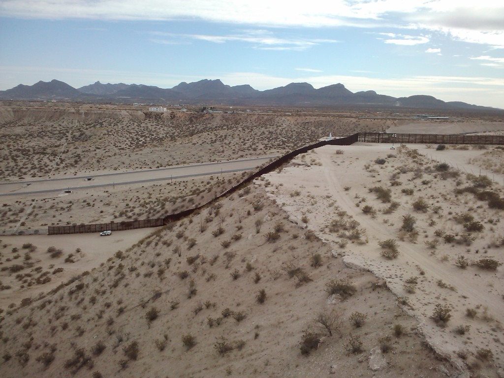
The border fence is visible in the photo
below and the broad open area in front that is convenient for enhancing your
top landing skills. It is the safest spot in the region to practice
this. View here is to the south. The international border is the
dark fence.
![]()

