
Introduction to weather in southeastern Oklahoma
by Had Robinson & Tom Bird, Senior Meteorologist, National Weather Service, Santa Teresa, NMupdated April 21, 2023
When is it safe to fly?
The information below is primarily for the southern central U.S. but most of it applies to everywhere else.
With all forms of paragliding, it is not so simple to answer the question of when should I fly? Firstly, the weather conditions have to be safe. That is, conditions must be within the pilot's comfort margin and skill level. His flying equipment must be appropriate for the conditions. Secondly, the pilot must consider the strength of the thermals at the time he is in the air. But why stay out of the air? Read this report and you can decide.
(6) Steps for studying the weather that can help you fly safely
- PG pilots can generally fly safely in the south central U.S. anytime during the day. That is, thermal strength is generally
not an issue.
- When it is summer and things start to really dry out, pilots have to be more concerned about thermal intensity and accompanying shear turbulence during the heat of the day.
It can also mean that dust devils may form, a particularly dangerous type of thermal for ultralights.
- If it is overcast or there is substantial cloud cover, thermal strength will be much less, even negligible. The "5-5 Rule" (no
gusts greater than 5 mph in less than 5 seconds) is an excellent rule. Strong thermals out in front of launch will cause blocking of
incoming air and pilots can know how strong the thermals are. The more laminar the air is at launch, the weaker are the thermals you
will encounter in the air and the less gusting there is at launch. PG pilots have to be careful that their skills and thermal
strength are in agreement.f
- If things like
dust devils,
virga, and
towering
clouds are present, DO NOT LAUNCH. A good rule concerning virga is: if you can see it, stay at launch or get to the ground ASAP. Most of the time virga has no effect on us but why
test Providence?
- If the
Jet Stream
or high velocity winds are high in the atmosphere, thermals can cause this high velocity air to mix with the air below and cause turbulence,
especially if there are pressure waves moving
through the atmosphere.
It is best not to launch, especially if you are in the
mountains. The Jet can cause serious turbulence near the surface. Sometimes it can be deadly. If there is a substantial inversion between you and the Jet, you will most likely be OK and
Jet turbulence will be isolated
above the air mass you are flying in. The
NWS hourly forecast
(3rd and lowest panel) gives a good estimate of the mixing height of the air we fly in and the presence of turbulence near the ground.
NWS meteorologist, Tom Bird, gives this good advice about the Jet.The Jet is more of a concern: 1) most days in the warm season when there is no inversion (or it breaks) and we get deep mixing...which causes strong winds aloft to come down to the surface. 2) in the cool season when an upper-low pressure system is passing causing instability to transfer the momentum aloft downward toward the surface.
- If you get past the above (5), then do the following:
a.) NWS Le Flore county forecast Look at the 7-day forecast. It is good to know if changes are in store, like a sudden appearance of a front which can mean turbulent air. The forecast may say that the front is due here at 2200 (10:00PM) local time. However, the front may get here at 1700 (5:00PM) when you are in the air. In other words, give yourself plenty of margin both weather-wise and time-wise.
b.) NWS hourly forecast Look at the wind speed, direction, and temperature trends over the day. Stay OUT OF THE AIR if there is gusting forecasted when you want to fly or it wind speed picks up during the afternoon and evening. If gusting is forecast, it generally means some disturbance (trough or ridge) is passing overhead. If winds are more than 12 mph, you can expect substantial and possibly dangerous turbulence on the lee side of thermals. High winds, in general, will cause weak thermals to break up = turbulence. If the winds are other than calm or light, a change of wind direction can complicate everything, especially at launch and when landing.
c.) MesoWest stations Ouachita Mountains This is a helpful site in seeing what may be ahead in the short term and knowing the weather conditions of stations in our area. To see what is going on in our region: Set "Network" to "All Networks", Overlays 1 & 2 to "Current Wind Speed" and "Current Wind Gust", respectively. Set the Radius tab to 150 miles. Click "Refresh Map". Zoom in to see what is going on in your particular area of interest, especially what the conditions are UPWIND of your location. To see the trend over 24 hours, click on the desired weather station and then the "wind" tab to see how the speed and gusts are trending. Click on the "Vector Wind" tab to see the trend in wind direction. Note: the data at some sites may be over an hour old. Some stations have a history of reported conditions.
d.) OPTIONAL NWS Raw Atmospheric Soundings These are the real-time balloon soundings and not a forecast of what's going on in the atmosphere. Here is the explanation of how to use this important information. If you see high winds (>50 mph) anywhere in the atmosphere, exercise caution. Everyone who has flown for years will tell you that there are still completely inexplicable atmospheric events that can be hazardous. Just once in this pilot's flying career, 50 mph winds were encountered right at the surface to 100 feet AGL. The day had been characterized by moderate laminar winds and then BAM. Landed going backwards but no damage or injuries, thankfully. An hour or so later, it was gone. No one, including the NWS, has an explanation to this day. Location: northwest of Del Rio, Texas on the Mexican-U.S. border.
e.) OPTIONAL Study Windy Take a look at the three different models (NAM, GFS, and ECMWF). If they are different, it basically means that each of them could be right, depending on local conditions. When conditions are light and variable, wind direction and speed can be all over the place. Another site widely used by meteorologists is Pivotal Weather where you can choose among various models and see a national map of where the high and low pressure systems are and where they may be moving. These systems are what drive the winds we experience near the surface.
f.) OPTIONAL but highly recommended XCSKIES Subscribe and check what the thermals will be doing and, especially, the wind speed and direction at the altitude of where you plan to launch, fly, and land. Forecasts with multiple models are easily checked. Which model? When? Study the help files to learn information that can save your life. The buoyancy to shear ratio is helpful for determining the level of turbulence you can expect. If you do not have a computer, you can listen to the National Weather Service broadcasts. These frequencies can be accessed by many radios. Pilots may call WXBrief via a cell phone and speak with a trained weather analyst. It is free and the analysts are always helpful.
g.) OPTIONAL RADARSCOPE but highly advised Radarscope is a professional app that runs on iPhone and Android cellular phones and is now available for Windows and Mac. The app ties in to all of the NWS radars in the northern hemisphere. It gives REALTIME data on storms and wind direction/velocity. Where is the hail coming down? Are there any gust-fronts headed this way? Where is rain and what is its intensity? It costs about $10/year. Here is a video of a sudden increase of winds to over 30 mph just above the surface at the end of the day. (The brighter the green, the higher the winds.) It came out of nowhere. - If everything looks good to this point, go fly. Always
remember that the forecasts can be incorrect because of the nearly infinite factors that cause changes in the weather near the surface. The only SURE data we
have are the balloon soundings and our own observations. For $40
a pilot can go by Party World and pick up a helium
cylinder, some balloons, and be your own weatherman (sort of). It is amazing
what we have observed sending up our balloons over the years. Read on for some general information on what constitutes "safe
conditions". Remember that you must make the decision to fly or
not – it is solely your responsibility. If in doubt, STAY ON THE
GROUND.
- Too many PG pilots (especially PPG pilots) are careless when it comes to assessing weather conditions. "Whatever...it looks OK at the moment."
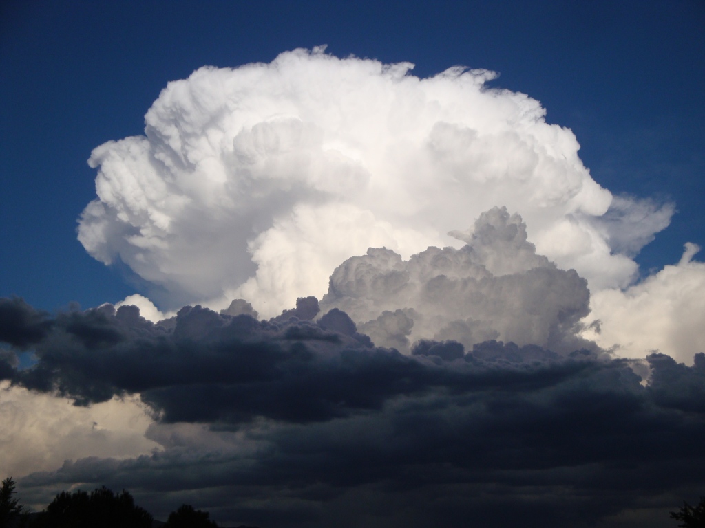
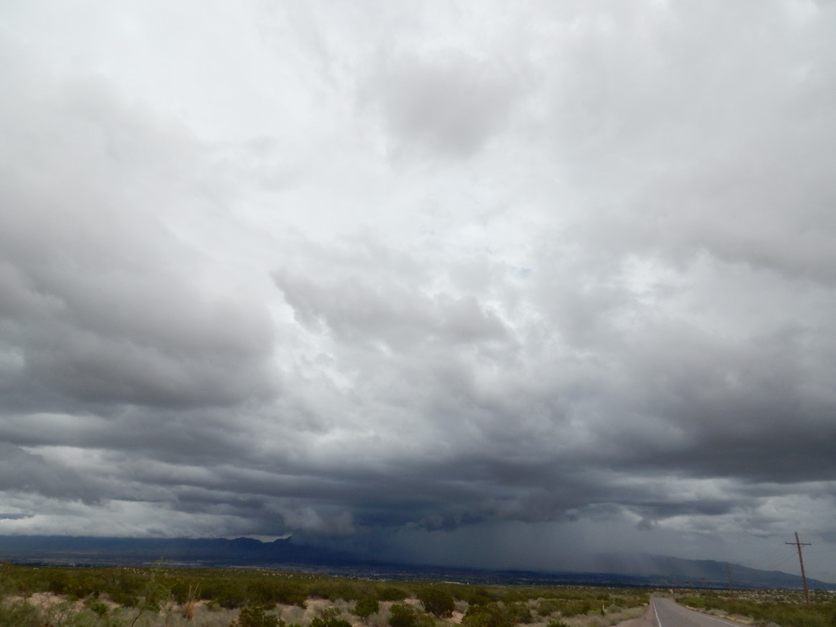
Below, an atomic bomb of energy – A powerful, towering cumulonimbus cloud. Ordinarily, moist air is heated near the ground, rises, and condenses completely into a cloud at the altitude known as cloud base. Cloud base is the altitude where the dewpoint and temperature of the air are the same. However, here the conditions are just right and there is plenty of warm moist air that is still condensing into water droplets at cloud base, releasing more heat. The air is gaining even more upward velocity and is able to penetrate the colder air above (the warmer a gas is, the more buoyant it is). It will keep moving up in a vicious cycle, condensing, releasing heat, and going higher until there is no more condensable moisture in the air mass. Wind velocity inside these monsters can exceed 100 mph and the cloud can top out at over 60,000' high. When the rain droplets/hail get heavy enough to overcome the upward wind velocity, we have precipitation that reaches the ground. Pilots have been sucked into these clouds and trapped – with often unhappy results. Even heavy aircraft stay away from them.
Wind Speed & Direction
Surface winds should not be more than 17 mph for foot-launched PG, much less for PPG, and even less flying a trike/quad. These are only estimates – it's up to the pilot to decide what conditions he is comfortable in. Always be sure to check the winds aloft before launching as we need to know what's going on above us. In particular, winds aloft may be 180 degrees different than at the surface. If these winds are strong, they may mix (cause turbulence) above launch and problems in trying to bench up from our mountain sites. Is there an inversion aloft which can isolate the strong air above? The balloon soundings will let you know. If barometric pressure is dropping or low, we can expect more buoyant air which is more fun to fly in.
Clouds
If there is 50% cloud cover, for example, thermals will be suppressed and we can enjoy calmer air all day long. However, the clouds must not be towering nor threatening rain, virga, or hail. Sunny clear weather pretty much guarantees the presence of thermals and turbulent air so we have to be careful what time of day we launch. Inversions in the atmosphere almost guarantee that thermals will not rise above the top of the inversion. As the day continues, the air near the ground will be turbulent everywhere as the hotter shallow air mixes with the air aloft. In the fall and winter, the heating of the sun is much less and thermals and turbulence will be weaker. It is often possible to fly all day during this season. We like thermals but ones that are not too strong because of the accompanying turbulence which is near them. This turbulence can easily collapse a paraglider.
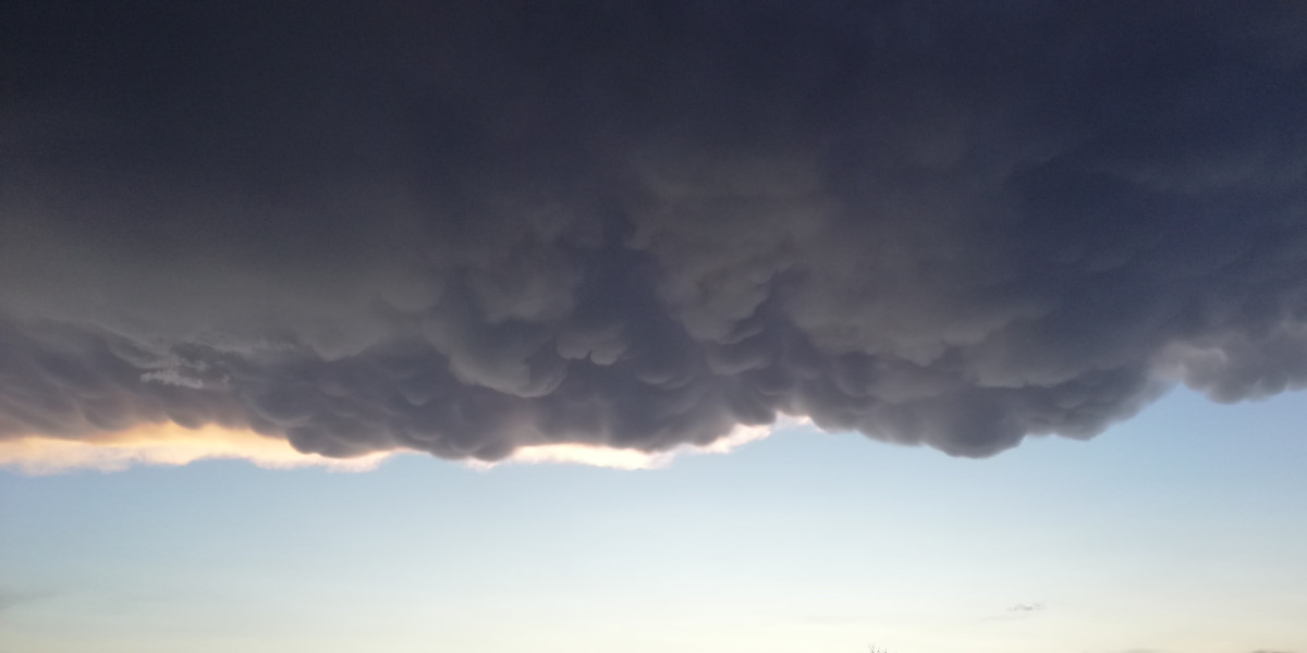
Mammatus clouds – it would not be a good idea to fly near these....
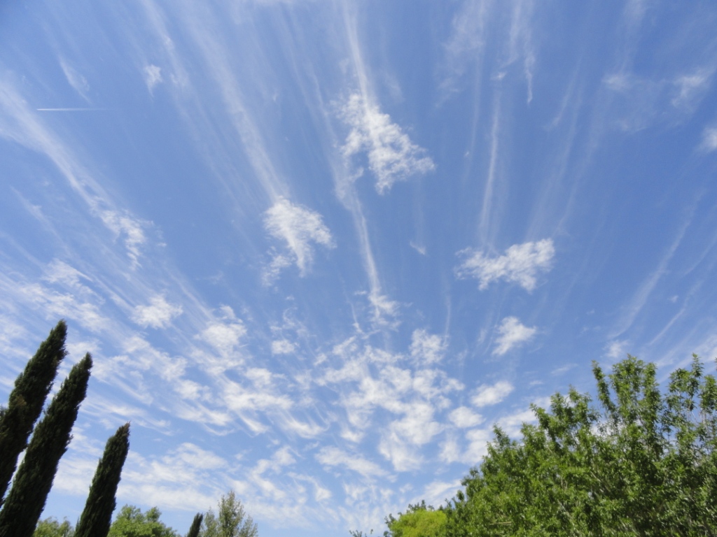
Cirrus clouds – these clouds were formed hundreds of miles away and were subsequently subjected to mixing from high winds aloft and were shredded.
A downpour from a powerful cell over the Franklin Mountains in west Texas. Storms like this one can cause dangerous flash floods as well as causing virga that is dangerous to ultralights.
Conditions favorable for PG (free flying)
We like modestly strong thermals that average around 800'/min (the pilot would be going up at 600'/min because his glider is sinking at about 200'/min. When the air is stronger than this, we risk a collapse of our glider because of turbulence in the vicinity of the occasional thermal which may be much stronger than average. Low barometric pressure encourages thermals to be more organized and smooth, rise more easily, and gain more speed. There is less turbulence near thermals during low barometric pressure conditions. If the lapse rate (the normal cooling of the atmosphere with altitude) is also "steep", it will guarantee that the thermals will ascend to great altitudes in the troposphere and a pilot will be able to also get very high. Inversions (where the air becomes warmer with altitude) can stop the rise of thermals like a brick wall and, consequently, can limit the height which a pilot can also rise. Some thermals are so strong that they can penetrate an inversion. If a pilot is lucky enough to find such a strong thermal, he can go right up with it and leave other pilots thousands of feet below.
With high barometric pressure, thermals tend to be sharp edged with turbulence between areas of ascending and descending air. This vertical shear can cause collapses in a paraglider as the pilot moves through them. They usually spontaneously recover but are not an enjoyable event when they occur. While the average strength can be 800'/min, for example, an occasional "boomer" can drift through which can be much, much stronger than the average (1,200'/min, for example). There are tools, like XC Skies, that can help us estimate the average strength of the thermals for the day. If we fly too early or too late, we will not find lift. If we fly in the middle of the day during late spring, summer, and early fall, we may find thermal strength to be excessive. What is excessive for one pilot may be too little for another – this is what flying skill and knowledge is all about. If we can find ridge lift (when air hits a vertical surface, like a cliff) we prefer to fly either very early or very late in the day as we do not need the presence of thermals to stay up. However, it is never wise to fly in thermals and ridge lift at the same time as the ridge lift tends to concentrate or merge thermals.
Conditions favorable for PPG (powered paragliding)
PPGer's usually prefer calm air which means launching near dawn or in an inversion. Typically, the air does not get excessively thermic during the late spring, summer, and early fall until about 10AM, daylight time. This can vary, however, but pilots can tell when the air starts to get active and they can then choose to land. Things start calming down around 5:00PM. The air is always the calmest at dawn. Modest thermic activity will make the air turbulent but it is not dangerous. If you never want to experience a collapse, fly at these times. If you fly at dawn and are also within an inversion, you will experience the calmest air possible. (See below for info on flying in an inversion.)
Zulu time – what is it?
The time of all weather related info is often given in "Z" (zulu), "UTC" (universal time coordinated) For example, it is (5) hours later than CDT and (6) hours later than CST. Here is an easy to read chart published by the NWS of U.S. local times converted to UTC time. GMT time can be different than UTC because the former time zone observes daylight savings time.
Miscellaneous
Altitude and air pressure are often expressed in millibars. Here is a millibars to feet conversion table. Here is a millibars to inches of Hg. conversion table (barometer readings). Go here for an explanation of weather symbols and how to do a surface weather analysis.
Two fronts (bodies of air) colliding near Ft. Davis, TX. Warm moist air from the Gulf of Mexico meets cooler dry air from the Rockies. The cool dry air is heavier and "slides" underneath the warm moist air, lifting it. It cools and condenses into clouds/fog/rain and gains the energy to move up even more gaining more energy. This sort of event is hazardous for soaring pilots if they are flying in the vicinity. The shredded clouds indicate high winds at that altitude. It would not be fun to be flying an ultralight anywhere near this sort of weather.
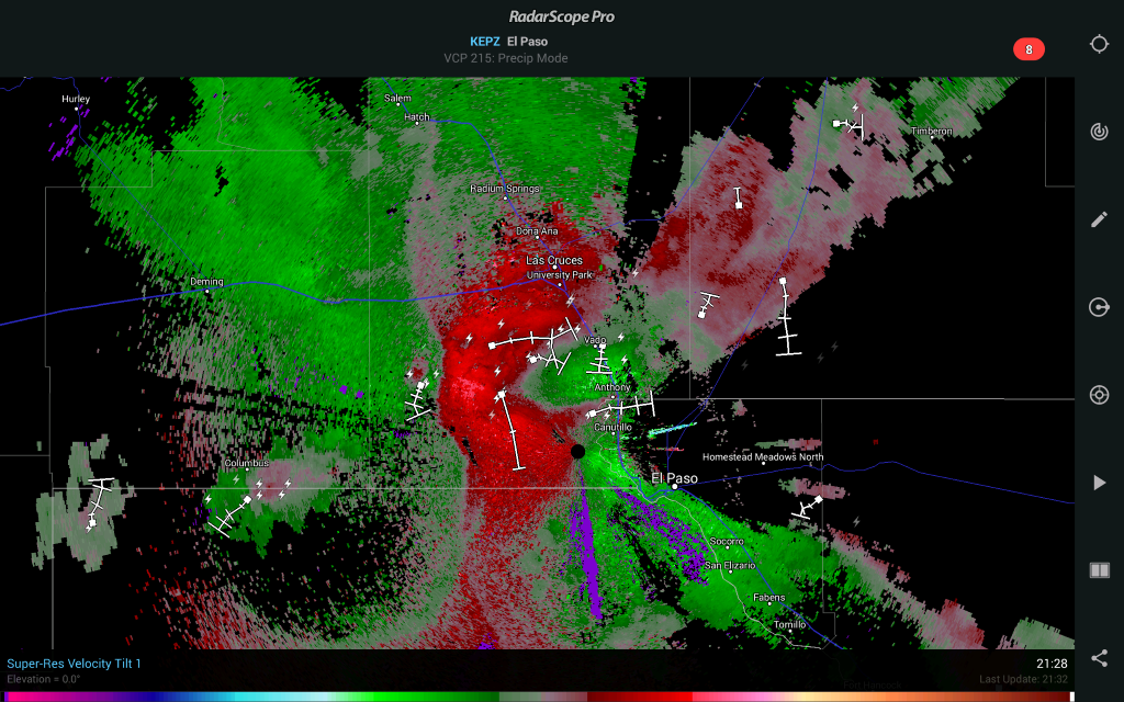
Below is a sample Radar Scope image of wind direction and velocity from the NWS in El Paso, Texas. The black "dot" is the radar location. The winds coming to the radar are green, the winds going away are red. The intensity of the colors indicates the speed of the air. The white lines with dashes across them indicate the location of major storm cells. The white square at the end of the white line is the current location. The white dashes indicate the movement and direction of the cell over a period of 15 minutes. The purple in the image is scatter of one kind or another and can be ignored.
It is obvious why ultralights stay on the ground when storms are near. Notice the ABRUPT change in wind direction near the storms just west of the radar. The surface winds were strong that evening from the southeast, in the low 20's. The power of the storms changed the direction and speed 180 degrees in mere yards.
Daily Wind Patterns
At the end of the day, sudden cooling of the air in the mountains will cause to flow downhill with considerable speed. Often, the winds near the base of mountains will be the reverse of the air 25' above the ground. This is why it is good to have windsocks in the LZ and pay attention to them.
![]()